Thursday, May 23, 2019

Iceland - Ring Road north

We booked an 8:30 boat tour from Húsavík to see whales and puffins, so no time for the geothermal pool in the morning. On the boat, we donned the provided 1-piece suit over our coats. The boat went first to an island with many puffins, then went looking for whales. We saw a humpback whale surface a number of times, then moved to a different location and briefly saw a harbor porpoise. We didn’t have a high-end camera and lens like many of the passengers, so don't have the best pictures.

It's a 45-minute drive to Ásbyrgi canyon, but we did it, and did the short hike at the base by the pond and a longer hike along the base and top of one of the sides. It looks like Þingvellir and tectonic plates, but the ranger said no, the cliffs were formed by the river. 

Next was the 37-foot-high 520-foot-wide horseshoe-shaped Goðafoss waterfall. The west side was closed for renovations, but views were good from the east side. The flow was high, so water went horizontally before dropping vertically.

The only toll on the Ring Road is a tunnel east of Akureyri. We drove an extra 15 minutes over the mountain to avoid the ISK 1500 toll.

Dinner was at Noa Seafood in Akureyri. We both had the catch of the day, which was spotted wolf fish in a very tasty sauce.


Wednesday, May 22, 2019

Iceland - Ring Road northeast

We needed ice for the cooler. An N1 gas station didn’t sell ice but was kind enough to give us some.

Our first stop is the 305-foot-high 35-foot-wide stair-step Rjúkandi waterfall. It's visible from the road, but a short walk gives a better view.


Next is the 167-foot-high 560-foot-wide Dettifoss waterfall, one of the most powerful in Europe. Route 864 on the east side wasn't open, so we approached from Route 862 on the west side.


Just upstream from Dettifoss is the 44-foot-high 1700-foot-wide horseshoe-shaped Selfoss waterfall.


While eating lunch at a picnic table, we saw a father and daughter from Richmond VA we met the first night, so chatted with them. They are doing a similar trip. We also picked up a hitch-hiker leaving Dettifoss who was born in France, so Carrie chatted with her a bit in French.

The Krafla caldera is north of the Ring Road and has a geothermal power plant, lava fields, and the Viti crater. The power plant is Iceland's largest, 60MW. We skipped the lava fields but saw the bright blue-green lake in Viti crater.


Not far away is the Hverir Geothermal Site, which has bubbling pools of mud and steaming sulfur fumaroles. Phew-ew!


I've never watched Game of Thrones, but apparently Grjótagjá cave is a thing, so we stopped for a quick peek. It's a geothermal pool in a cave.


Dimmuborgir (translated "dark forts") is a lava field with caves and interesting formations. One lava tube looks like a church.


The Mývatn Nature Baths are geothermally-heated pools, so we stopped for a 2-hour soak.


The bed-and-breakfast tonight has its own natural geothermal pool, so Carrie did a second soak. A couple staying in the B&B were French, so Carrie took another opportunity to practice her French.

Natural hot spring behind the B&B


Tuesday, May 21, 2019

Iceland - Ring Road east

Leaving the hostel, today's drive follows the coast for awhile before the Ring Road turns inland. Like yesterday, there is high fog but it is still beautiful. The first stop is the colorful town of Seyðisfjörður, which requires driving on a spur road over the Fjarðarheiði mountain through thick fog. We walk the town to see the colorful buildings and blue church.

We went to the Skaftfell art exhibit, which had about a dozen quirky collections. We also hiked to Tvísöngur, which is a 5-dome structure with interesting acoustics.


We had time for a 2-hour hike, so stopped at the visitor center and were recommended Vestdalseyri, a hike up a large stream with cascades and waterfalls that starts on the north side of the bay near old ruins. So we did it, and it was the nicest Iceland hike so far.


Next we drove inland back through fog to a 3-mile uphill hike to the 386-foot-high 35-foot-wide Hengifoss waterfall cascading over volcanic bedrock with red bands.


We were planning to food shop, but we can go a few more days. Dinner was ramen noodles with egg.
 

Iceland - Ring Road southeast

We returned to the Vatnajökull National Park in the Skaftafell area to walk to a glacier.

On to Diamond Beach, where lots of iceberg chunks from the glacier wash ashore. Light rain started during the drive and continued most of the day. 

Across from Diamond Beach is the Jökulsárlón, which literally means glacier river lagoon. A boat tour gives a close-up of the icebergs and glacier. The blue color is from compacting out the air. Black streaks may not be dirt but layers of ash from volcano eruptions - the ice is hundreds of years old.

Höfn, which means harbor, is a fishing and tourist town. It also has a national park visitor center with 2 videos, a good place for a rainy afternoon. 

The coastal drive has high fog but is beautiful. We even saw what we think are reindeer.

Djúpivogur, a small town surrounded by 3 fjords, is perhaps best known for its egg sculptures, one for each species of seabird. 

Sveinsstekksfoss is a 49-foot-high 35-foot-wide waterfall and Folaldafoss is a 54-foot-high 15-foot-wide waterfall. In case you haven't caught on yet, "foss" is Icelandic for waterfall. These 2 are afterthoughts in Iceland but would be major attractions most other places. 

We’re using google maps and were surprised to see a traffic slowdown reported ahead of us on a deserted road. When we reached it, there was 1 car pulled over to take a picture, so we did likewise, confirming to google that there really is a traffic slowdown. :)

Like last night, we stay in a hostel far from town and like last night, we have the place to ourselves.

Iceland - Ring Road south

We ate another yummy breakfast of skyr, granola, and raisins. Carrie made rolex’s for lunch, which is a Ugandan dish, with fried egg rolled in chapati (well we used tortilla because Bonus didn’t have chapati :).

We stopped for gas at an unattended gas station. Many gas stations in Iceland are unattended and require a chip-and-pin card. Most USA credit cards require a signature and won’t work. Bill’s credit union debit card worked fine.

Our first sight is the 200-foot-high 50-foot-wide Seljalandsfoss waterfall. You can walk behind the waterfall and look through it, which is very cool.

Next is the 227-foot-high 100-foot-wide Skógafoss waterfall. It drops from the highland plateau to the lowlands over what was once the cliffs along the ocean shore. We walked up lots of steps to a viewpoint at the top of the falls and continued upstream past pretty cascades. There is a second large waterfall further upstream but the trail was closed. We had a snack of crackers and smurostur, which is an Icelandic product like flavored cream cheese.

Dyrhólaey was originally a volcanic island but is now a peninsula with a beautiful view and a lighthouse. Lots of birds nesting on the rock by the arch.

Reynisfjara is a black sand beach with basalt sea stacks. The cliff has hexagonal rock formations formed as lava cooled.


We saw 2 guys hitch-hiking, so we picked them up. They were both Polish and one spoke good English and worked in a restaurant and the other spoke only a little English and worked in elder care. Iceland’s population is about 350,000 and apparently 10% are Polish. They said the pay is better in Iceland than in Poland.

We planned to see Fjaðrárgljúfur, a beautiful canyon cut by glacial erosion about a mile long and 330' deep, walking the short trail to the overlook. But it was closed. That night, in my google "news for you" there was an article about the closure. Apparently Justin Beiber filmed a video there, off-trail and in the stream, so lots of people were doing the same and ruining the canyon. So it is closed and I have no picture to post. :( While google correctly highlighted an article that interests me, it’s creepy. Were they using my map destinations?

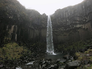
It was cloudy all day, but a light rain started before Vatnajökull National Park. Undeterred, we stopped at Skaftafell for the S2 hike. It’s a 3.4-mile walk past the 78-foot-high Hundafoss waterfall and 31-foot-high Magnúsarfoss waterfall to the 65-foot-high Svartifoss waterfall, where water falls over black basalt columns.

Dinner was soup and tuna melt, cooked in the hostel’s nicely equipped kitchen. There were no other guests in the hostel.  Nearby the hostel was a small church.


Monday, May 20, 2019

Iceland - Golden Circle


We arrived at Keflavik airport in the morning, bought an Iceland SIM card for Carrie’s phone and picked up a rental car. Iceland drives on the right side of the road same as the United States, but we do need to use headlights all the time.

First stop is to buy groceries at Bonus, so we looked for the pig with the black eye. One of the things we bought was skyr, which is a tasty Icelandic product similar to yogurt. So we ate a late breakfast of skyr, granola, and raisins in the car.

Next is Þingvellir National Park. Here the North American and Eurasian tectonic plates collide above sea level, so you can see the edges of the plates.

Þingvellir is also the site where tribal leaders met yearly starting in 930 AD to govern and established one of the two oldest parliaments in the world.

Carrie is vegetarian, so we went to the Friðheimar restaurant for a late lunch. Iceland imports much of its food, but this farm grows their own greenhouse tomatoes and makes a very fresh tomato soup. Lunch is served in the greenhouse.

Kerið is a volcanic crater lake that we hiked around.

Geysir is Icelandic "to gush" and is the origin of the word geyser. Geysir the geyser still erupts occasionally, but the most consistent geyser in the area is Strokkur, which erupts about 50 feet high every 6-10 minutes. Some springs have a bit of color and some bubble, so it is like Yellowstone on a smaller scale.

Our last sight for the day is Gulfoss, the golden falls, a 105-foot-high 750-foot-wide 2-step waterfall.

After arriving at the bed-and-breakfast, Carrie made a cheese quesadilla for dinner. Bill didn’t sleep much on the flight, so he just went to bed.


Friday, May 17, 2019

Iceland - off we go

Hurray! Hurray! Our Iceland vacation starts today!

Bill and Carrie are flying to Iceland tonight for an 8-day 1400-mile counter-clockwise drive around the Ring Road. Our planned sights are mostly outdoor scenery that only requires a short hike, which includes lots of waterfalls. We will be staying in bed-and-breakfasts and hostels along the route, cooking most of our meals and eating out a few times.


Carrie has visited over 25 countries and is the seasoned traveler. Bill hasn't flown for over 20 years, so all this TSA stuff is new to him. 

The weather prediction is 50's F in the day and 40's F at night, with rain possible this weekend. Sunrise is 4:05 AM and sunset is 10:43 PM, so plenty of daylight.

We have lots planned, but will try to post along the way.