We
ate another yummy breakfast of skyr, granola, and raisins. Carrie made rolex’s
for lunch, which is a Ugandan dish, with fried egg rolled in chapati (well we
used tortilla because Bonus didn’t have chapati :).
We
stopped for gas at an unattended gas station. Many gas stations in Iceland are
unattended and require a chip-and-pin card. Most USA credit cards require a
signature and won’t work. Bill’s credit union debit card worked fine.
Our
first sight is the 200-foot-high 50-foot-wide Seljalandsfoss waterfall. You can
walk behind the waterfall and look through it, which is very cool.
Next
is the 227-foot-high 100-foot-wide Skógafoss waterfall. It drops from the
highland plateau to the lowlands over what was once the cliffs along the ocean
shore. We walked up lots of steps to a viewpoint at the top of the falls and
continued upstream past pretty cascades. There is a second large waterfall
further upstream but the trail was closed. We had a snack of crackers and
smurostur, which is an Icelandic product like flavored cream cheese.
Dyrhólaey
was originally a volcanic island but is now a peninsula with a beautiful view
and a lighthouse. Lots of birds nesting on the rock by the arch.
Reynisfjara
is a black sand beach with basalt sea stacks. The cliff has hexagonal rock
formations formed as lava cooled.
We saw 2 guys hitch-hiking, so we picked them up. They were both Polish and one spoke good English and worked in a restaurant and the other spoke only a little English and worked in elder care. Iceland’s population is about 350,000 and apparently 10% are Polish. They said the pay is better in Iceland than in Poland.
We planned to see Fjaðrárgljúfur, a beautiful canyon cut by glacial erosion about a mile long and 330' deep, walking the short trail to the overlook. But it was closed. That night, in my google "news for you" there was an article about the closure. Apparently Justin Beiber filmed a video there, off-trail and in the stream, so lots of people were doing the same and ruining the canyon. So it is closed and I have no picture to post. :( While google correctly highlighted an article that interests me, it’s creepy. Were they using my map destinations?
It
was cloudy all day, but a light rain started before Vatnajökull National Park.
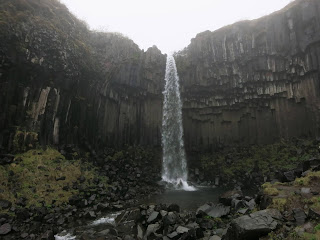
Undeterred, we stopped at Skaftafell for the S2 hike. It’s a 3.4-mile walk past
the 78-foot-high Hundafoss waterfall and 31-foot-high Magnúsarfoss waterfall to the 65-foot-high Svartifoss waterfall, where
water falls over black basalt columns.
Dinner
was soup and tuna melt, cooked in the hostel’s nicely equipped kitchen. There
were no other guests in the hostel. Nearby
the hostel was a small church.


