Tuesday, July 9, 2019

Newfoundland – Last Day


Corner Brook
We camped at Corner Brook – the third largest city in Newfoundland, situated at the end of the long Bay of Islands between the mountains. Since we had time before we had to checkout, we hit a couple trails.

The first was a short hike to Steady Brook Falls.
Sometimes we spot interesting things along the way.
Second we walked the pathways by Margaret Bowater Park, which skirt a stream and pond in the middle of the city. A beautiful day for a stroll on really nice city paths.


The Granite Coast
We headed back to the provincial park we first stayed at when we arrived in Newfoundland – close to the ferry. We didn’t have time to drive the coastal road beyond the ferry the last time we were here, but this time we did. It’s an interesting drive. Bill said, “The land has wrinkles.” Lots of twists and turns as the road goes through an almost tree-less granite landscape with frequent ponds, distant views of the Atlantic and occasional harbor towns. Along the way we stopped for a short boardwalk hike to Barachois Falls.
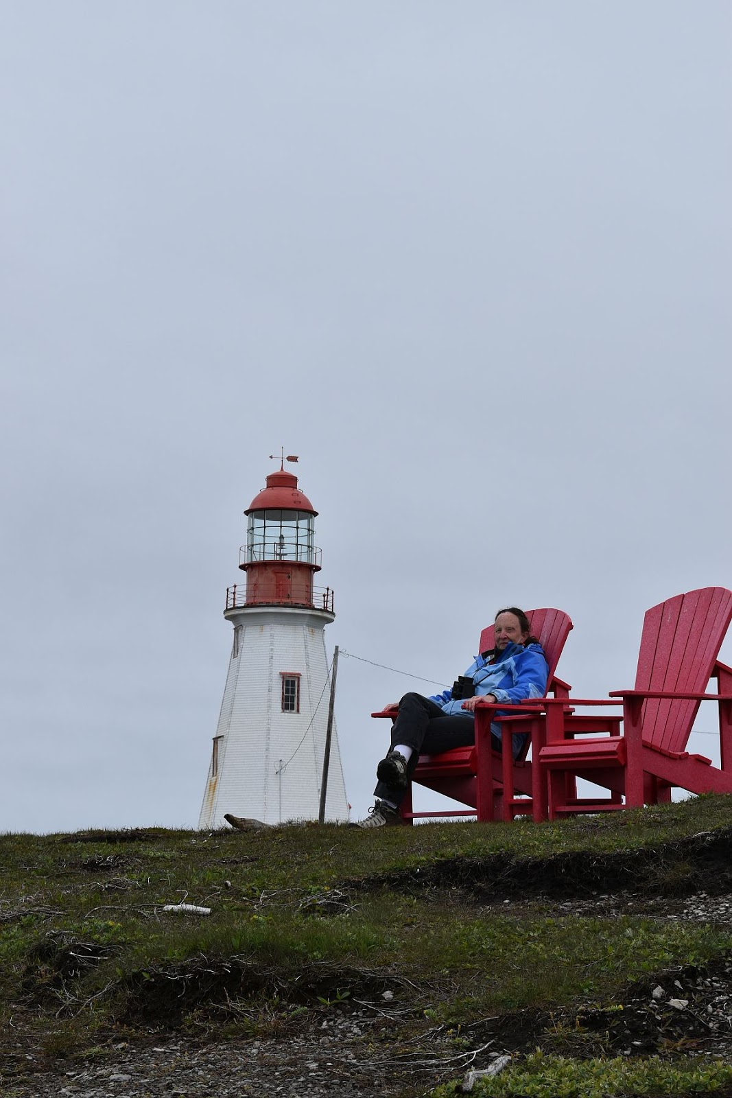
Wildflowers lined the path, including many pitcher plants and some lady slippers.

The road ends at the small fishing village of Rose Blanche where one can see the restored Rose Blanche Lighthouse. The lighthouse was in operation until the 1940s when it was abandoned. By the 1980s the granite building fell into ruins except for the tower which was supported by a stone spiral staircase. A major restoration effort culled through the rubble to rebuild the lighthouse with mostly the original granite blocks and opened in 1999.
You get nice coastal views from the lighthouse.
There is actually another town beyond Rose Blanche, but you can only get there by boat. That’s like many coastal communities used to be in Newfoundland.

After dinner we took a walk on the same beach we walked when we arrived. 

Tomorrow we leave Newfoundland…

Monday, July 8, 2019

Newfoundland – Bay of Islands


A brochure for this region says,
Come walk the trails of the south shore of the Outer Bay of Islands which many say are the best kept secret in Newfoundland.
This is another coastal region with islands and little harbor towns nestled in coves with scenic hiking trails. We explored four trails in the area.

Copper Mine Falls
We thought we’d give the short trail to Copper Mine Falls a try. Bill read a trail alert that said a portion of the trail got washed out last year, but a recent review made no reference to the washout. Maybe it’s okay now?

We ran into a couple as we started that confirmed the trail was washed out, but said, “There is a rope.” When we came upon the washout we could see what they were talking about. Someone had installed a makeshift guardrail and a rope to hold while traversing this slanted slippery slope. Barbara chickened out, but Bill negotiated his way to the falls.

Governor’s Stairway
When you get to the pebble beach at Blow Me Down Provincial Park it’s easy not to notice a hidden staircase tucked between the rock cliffs.


420 steps or so lead to viewing platforms.
No rock piles, but we did see this.

Bottle Cove
We’ve been on lots of trails, but never a trail that goes through a ship.
Captain James Cook charted the area in 1776 and referred to it as “Trail’s End” – the farthest point on this peninsula.
We loved the scenery here.

Cedar Cove
Last we took a two mile hike that brought us out at a remote cove. We were surprised that the trail was occasionally marked by sea trash (lobster buoys, plastic containers, a hard hat…). Should have gotten a picture, but we did get pictures of the cove.


Hard to believe, but this is our 250th post! Thanks for reading our blog. :-)


Saturday, July 6, 2019

Newfoundland – Vikings & More


You can’t come to the Northwest peninsula of Newfoundland without noticing an abundance of things related to Vikings. That is because a Norse settlement was discovered here in the 1960’s. In the decade around 1000 A.D. Nordic expeditions from Greenland used this area as a year-round base to search for resources, calling the land Vinland. They eventually abandoned it, setting it on fire as they left.

L’Anse aux Meadows National Historic Site and UNESCO World Heritage Site preserves this archeological property and shares this significant snippet of history with visitors.
When we first arrived we went up the hill to see what all these Norse people were looking at. Barbara thinks they were all looking for a letterbox, since there was one in that direction. HaHa.

We checked out the visitor center with its interesting displays and then took a ranger-led tour through the archaeological site.
The tour ended at a reconstructed Norse settlement with its sod houses where living history interpreters explain aspects of the settlement.
The Norse knew how to fashion iron and there is evidence that they smelted bog ore into iron nails for boat repair here at this site.
We should also mention what we saw before and afterward. On the way to L’Anse aux Meadows we spotted two icebergs. The channel here between Newfoundland and Labrador is known as Iceberg Alley.
After the tour we asked about the hiking trail. The ranger gave us the details and told us people just saw a momma moose and 2 babies. “Let’s go!” So we took the trail and looked for moose. We’ve done a lot of looking for moose while in Newfoundland. We saw some fresh moose tracks, but no moose. We did see – what we always see in Canadian National Parks – red chairs!
We got a glimpse of Labrador in the distance. And we came upon some snow. It’s July 5th! So we made a snowman.
As we were leaving the park we noticed cars pulled off to the side of the road… Finally … Moose!
We ended the day with some partridgeberry topped carrot cake from Dark Tickle for dessert. A gal we met on the trail a few days ago highly recommended it, so we had to give it a try. Yum!

Friday, July 5, 2019

Newfoundland – Northwest Peninsula


Today we drove from Gros Morne all the way up the Northwest peninsula, breaking it up with two stops along the way. Fortunately the parking lots had enough room to accommodate a car with a trailer.

Arches Provincial Park
We first stopped at Arches Provincial Park – a park that preserves some natural arches. We walked around and took some pictures. 

Port aux Choix
Our second stop was Port aux Choix National Historic Park, which preserves an archaeological site with evidence from four ancient cultures: the Maritime Archaic people (3000+ years ago), the Grosswater & Dorset people (1000-3000 years ago), and the ancestors of what we now consider the First Nations people. We started in the visitor center where exhibits piece together the history and show some examples of artifacts found. It didn’t take long to read through all the exhibits.

A several kilometer hike or short drive brings you to the actual archeological sites. We drove down to the end of the peninsula with its lighthouse and evidence of a Dorset Village.
All that remains of the Dorset village are some depressions in the ground, but signs explain the history and wire sculptures help one imagine the scene.

Being a Canadian National Park we found some red chairs.
Probably the most fun part about stopping here was seeing a pair of caribou. They practically walked right up to us.
Then we drove to another part of the park where we hiked to Philip’s Garden along the Dorset Trail. Wire sculptures tried to help the visitor visualize the seal-fishing culture of the past since the only other evidence was slight depressions in the ground.
We walked through the unique limestone barrens and spotted some rare wildflowers.